
Loading…
Loading…
Upload a property list, see each record on a map, review GIS details, and keep your notes and next steps in one clean workspace.
Built for tax sale lists, county exports, foreclosures, tax deeds, REO, land lists, and other property research lists. You can sort leads, check map details, and keep your research clear without jumping between spreadsheets and county map sites.
Free Explorer includes 1 active dataset, up to 100 properties, and 30 days to try the workflow.
GIS and parcel details depend on the county you choose. Grades help you sort leads faster, but they are not legal, financial, or investment advice. See supported counties before you rely on enrichment for every row.
Real workspace preview
Map
Visual
Scores
Prioritized
Tasks
Organized
See every lead on a map
Turn rows into a visual property board when addresses or parcel IDs can be matched.
Review GIS details faster
Bring parcel and county data into the same place when that county is supported.
Find better leads first
Use grades and flags to sort the list before you spend hours digging.
Keep the work organized
Notes, status, reminders, and decisions stay tied to the right property.
Simplified property research
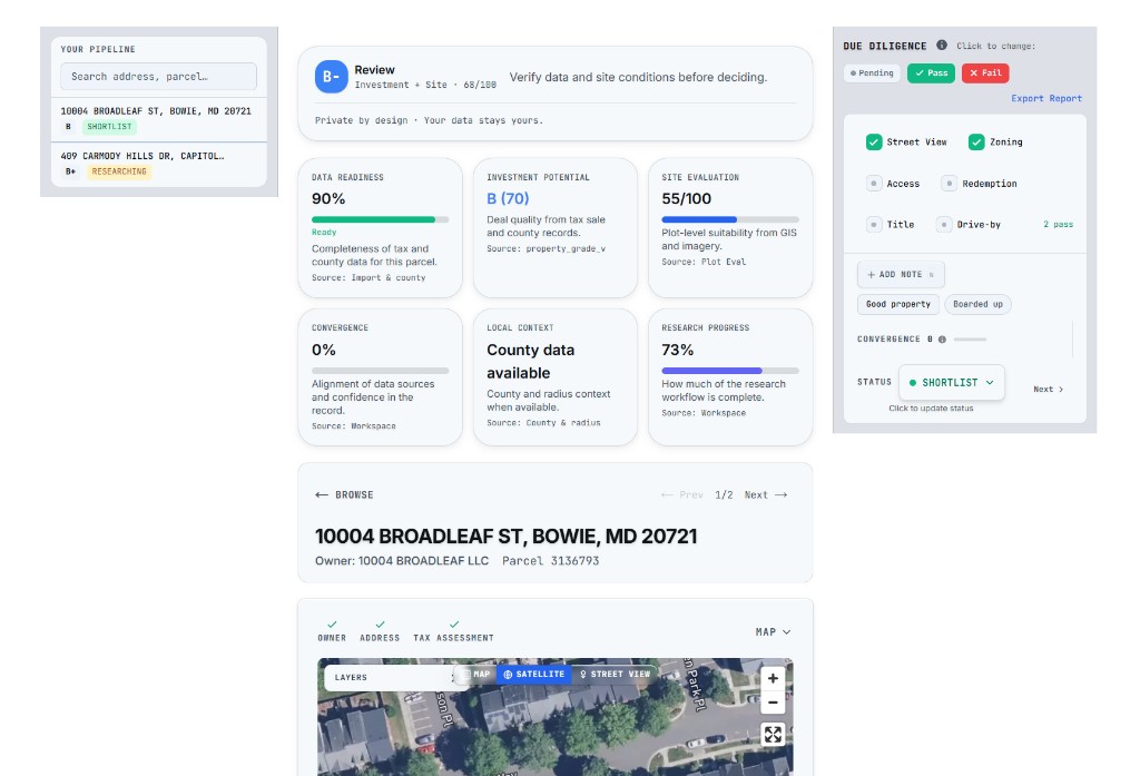
Plot Eval gives each property its own place for map context, GIS notes, status, reminders, and decisions.
Map results, parcel details, GIS layers, and grades depend on your county and data quality. Check Supported counties before you upload.
Map your property list
See records on a map and open each property with the details you need for research.
Keep leads organized
Use notes, status, reminders, and decisions so every property has a clear next step.
Know what data is available
Check supported counties before you upload so you know where parcel and GIS data may be available.
The old way
Investors often start with a spreadsheet, then jump between county sites, maps, notes, and browser tabs. Plot Eval brings more of that work into one place so you can review leads faster.
County records, maps, notes, and spreadsheets can pull your focus in too many directions.
GIS layers, parcel details, and lead notes are easier to use when they sit next to each other.
A good lead can slip away when reminders, status, and decisions are not tied to the property.
The new way
Plot Eval turns your property list into a map-based workspace. You can review leads, add notes, set reminders, and decide what to keep researching. GIS depth and parcel match success depend on the county you choose. See supported counties for details.
Start with a tax sale list, county export, or your own spreadsheet. Plot Eval helps line up the columns and keeps the original record tied to the property.
Use the list you already have
Plot Eval tries to place records on a map and add parcel or GIS details when that county supports it. Some counties have deeper data than others.
County support controls available data
Use the map to compare location, nearby context, and grade signals before you spend time on deeper research.
Review location at a glance
Open a property to review maps, notes, checklist items, reminders, and decision status. Keep the best leads moving.
Focus on the leads that matter
New here? See the full guideDistressed-property research curriculum
Your workspace
Each property gets a dedicated research workspace with map views, timestamped notes, a research checklist, status, reminders, and county-backed fields when enrichment succeeds. The Dashboard, Agenda, and Decisions pages keep follow-ups and pipeline context visible so you spend less time switching tabs.
See the property on an interactive street map with surrounding context — roads, parcels, and nearby landmarks.
Toggle to satellite imagery to see the actual lot, structures, terrain, and neighboring properties from above.
Drop into Google Street View to see the property from the road — assess curb appeal, road access, and neighborhood condition.
Add timestamped notes to any property. Tag them for quick recall. Your research history is always preserved.
Track due diligence with pass/fail toggles for zoning, title, liens, environmental, and more. See research progress at a glance.
When your county tier provides them and parcels resolve, see owner info, assessments, zoning, schools, flood zones, utilities, and road access—decoded into plain language. Coverage varies by jurisdiction.
Add deadlines and follow-ups on any property. See overdue and upcoming items on your Dashboard, open Agenda for a dedicated list, or use Calendar for a month view—so tax-sale dates and callbacks stay on your radar.
Mark confidence and decision status per property. Use the Decisions hub to review what you've short-listed, ignored, or put in progress across datasets without opening each row again.
Convergence scoring
Inside each dataset, when the same property is tied to more than one import or source type—think a tax sale upload plus a follow-up county pull merged onto one row—Plot Eval tracks that overlap and raises its Convergence Score.
A high score means the parcel keeps showing up across sources in that workspace. It is a prioritization hint to dig deeper, not proof of value or a recommendation.
Same property linked to 2+ imports or source types scores higher convergence
More data sources = stronger prioritization signal (verify before you act)
Filter and sort by convergence to find repeat opportunities
Example: 123 Main St
Tax Sale 2024
Jan 2024
County Export
Mar 2024
Your Spreadsheet
Jun 2024
Convergence Score
Seen in 3 sources (one dataset)
Organize your pipeline
As you research, mark each property with a status so you always know where it stands. Filter your entire dataset by status to focus on what matters.
High-potential properties worth pursuing. Your top picks.
Currently researching. Checklist in progress.
Interesting but not ready to act. Come back later.
Not a fit. Hidden from default views so you can focus.
Filter your browse view by any status to instantly narrow down your list. Combine with grade filters to find shortlisted A-grade properties in seconds.
The difference
Ready to evaluate smarter?
Upload your data, see it on a map,
and start making decisions.
Start with Free Explorer: one active dataset, up to 100 properties, notes, checklist, decisions, basic map access, and 30 days from your first property upload or add. Upgrade when you need exports, advanced GIS, multiple datasets, or team workflow.